


SALT LAKE CITY — The National Weather Service in Salt Lake City has issued a winter storm warning and advisory, expecting heavy snow and powerful winds throughout the state.
Snowfall is expected to roll in across the mountains Sunday, lasting through Tuesday.
Snow will start across the mountains of Utah Sunday lasting through Monday with lingering snow into Tuesday. A gradual transition from rain to snow will occur late this evening for valleys and continue into Monday, which could bring travel difficulties Monday AM (NWS)
It may begin as rain and transition into snow later Sunday evening. As the night goes on, there may be breaks but snowfall is expected to continue lightly Monday morning. Then, more snow showers are expected in northern Utah through Monday night.
The NWS warning states that there could be 6-12 inches in the Ogden Valley and Wasatch Back, with the heaviest snowfall between 5 pm Sunday and 8 am Monday, making for hazardous conditions to impact the morning and evening commutes.
Timing & elevations will be key across N. Utah valleys (where advisories exist) as cold air will be slow to filter in and a transition to snow could take some time for lower valley elevations. Additionally, snow totals are for the entire storm w/ breaks possible throughout. #utwx
— NWS Salt Lake City (@NWSSaltLakeCity) December 11, 2022
There is potential for 12-24 inches of snow to accumulate in the Wasatch Mountains, north and south of Interstate 80, beginning Sunday 11 am and lasting through 5 pm Tuesday.
Southern mountains will see snow 11 am Sunday to 11 am Monday, with 8-18 inches heaviest from 2 pm Sunday to 3 am Monday.
Western Uinta Mountains, Wasatch Plateau and Central Mountains snowfall is heaviest 5 pm Sunday to 11 pm Monday, with 6-12 inches expected.
All roads in the mountain routes will have winter driving conditions, according to the NWS warnings.
Southwest and South Central Utah might see 2-6 inches of snow, from 11 am Sunday through 11 am Monday. Winter driving conditions Sunday night through Beaver, Cedar City, and Milford.
San Juan Mountains and surrounding areas may see 6-12 inches of snow on top of 45 mph wind gusts from 5 am to 11 pm Monday, causing severe road conditions and reduced visibility with snow and winds. Wind chills could be as low as 20 below 0, which can cause frostbite on exposed skin in just 30 minutes.
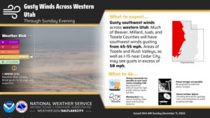
A High Wind Warning is in effect for southwest Utah and Tooele Valley through 8 pm this evening. Expect wind gusts to 58 mph, especially through early afternoon. Strong crosswinds on I-15 near Cedar City and east-west routes through the area. (NWS)
Tooele and Rush valleys and Southwest Utah are expected to have 30-40 mph winds. The NWS warns this could blow around unsecured objects and break tree branches.
60 mph winds have blown over a semi at milepost 71 on I-15 just north of Cedar City. High wind warnings for Beaver, Iron, and Tooele counties continue through 8pm. #utwx
— NWS Salt Lake City (@NWSSaltLakeCity) December 11, 2022
A detailed map can be found on the NWS Salt Lake City website.
Snow will start across the mountains of Utah Sunday lasting through Monday with lingering snow into Tuesday.
A gradual transition from rain to snow will occur late this evening for valleys and continue into Monday, which could bring travel difficulties Monday AM #utwx #wywx pic.twitter.com/y3rd14Los0
— NWS Salt Lake City (@NWSSaltLakeCity) December 11, 2022
Follow @BrookeWNews
Comments are closed.