

SALT LAKE CITY — Winter weather advisories are in effect as a storm moves into northern Utah, bringing strong winds and dangerously cold temperatures.
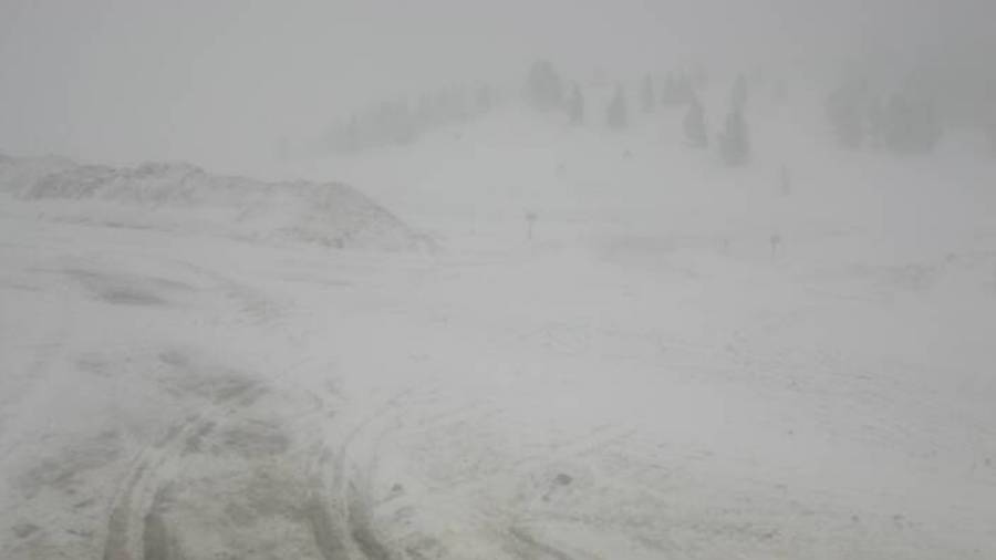
The heaviest snow is expected to fall in the Wasatch Mountains, which could see 6 to 12 inches of snow. Some parts could see up to 15″ of snow, according to the National Weather Service.
Remember some of this could start as rain!
— Matthew Johnson (@KSL_Matt) December 20, 2022
A winter weather advisory goes into effect at 2 pm Wednesday for the Tooele and Rush valleys, the northern Wasatch Front and Salt Lake Valley through 1 am Thursday.
These areas could see a trace to 3 inches of snow.
“Winter driving conditions are expected,” read the advisory. “The hazardous conditions will impact the Wednesday evening commute.”
(National Weather Service)
For anyone looking to travel east on Interstate 80, heavy snow and strong winds are likely throughout Wednesday afternoon and evening in Uintah County, Wyoming.
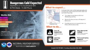
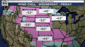
Sub zero wind chills
A wind chill warning will go into effect for the Cache Valley, eastern Box Elder County and the Wasatch Back at 8 pm Wednesday. It lasts through 11 am Thursday.
Temperatures could drop to -20 degrees in the Cache Valley and northern Utah, while the Uintah Basin and southwestern Wyoming could see temperatures of -35 degrees.
“The cold doesn’t bug me,” Jared Briggs said with a laugh. hey owns MyLife Financial in downtown Evanston where shoveling the sidewalk in front of his insurance business has become a big part of his job.
For as cold as it has been lately, what’s coming requires more than the sweatshirt Briggs was wearing.
“I mean, it’s cold, but when it’s negative 20, it’s another level,” he said.
Meteorologists say these cold winds could cause frostbite on exposed skin in as little as 30 minutes.
While not as drastic as parts of the Midwest, where temperatures will drop to 50 degrees below zero or even colder, this is dangerously cold weather.
There will be a “heightened risk to exposed skin, and to those without adequate clothing or shelter,” the NWS tweeted. “Avoid outside activities if possible. When outside, make sure you wear appropriate clothing, a hat, and gloves.”
A new warming center opened in Logan earlier this week.
Concerns about illness or inflation aren’t stopping Americans from hitting the roads and airports this holiday season. But a massive winter storm might.
Forecasters predict an onslaught of heavy snow, ice, flooding and powerful winds from Thursday to Saturday in a broad swath of the country, from the Plains and Midwest to the East Coast. A surge of Arctic air will follow. The Christmas weekend could be the coldest in decades.
High winds in Castle Country
📢 📢 📢 Dangerous, damaging wind gusts to 80 mph expected in Castle Country tonight/Thu AM for areas west of SR-10, including:
*Orangeville
*Ferron
*Fremont Junction
Prepare now! This is not your typical strong wind event. Let your friends/family know in the area. #utwx pic.twitter.com/wsIaW4yo8M
— NWS Salt Lake City (@NWSSaltLakeCity) December 21, 2022
Follow @https://twitter.com/jellis9
Comments are closed.