

SALT LAKE CITY — Another storm has moved into Utah bringing rain, snow, and avalanche dangers through Sunday.
“Rain will persist tonight and lead to periods of rain through the day on Saturday,” KSL meteorologist Matt Johnson said. “A switchover to snow is possible as cold air filters in through the day on Sunday.”
Saturday’s rain should not cause a problem for people headed to the Rose Bowl for Monday’s game. Drivers could face difficulties Sunday as that rain turns into snow.
“Heavy mountain snow is expected across all Utah mountains this weekend,” the National Weather Service said. “Significantly accumulating snow is also expected across the Wasatch Back, Bear River Valley, and Uinta Co., WY. Snow may mix with or change to rain at times on Saturday across lower elevations of the Wasatch Back.”
Johnson said the residents could expect one to two inches of snow in the valleys by Sunday with mountain areas bracing for as much as five feet. “This will likely push our snowpack to near 200% of normal,” Johnson said.
December has delivered the wet snowstorms that the state needs to build up snowpack, and ultimately help restore badly depleted reservoirs in the spring. Of course, this weekend’s storm will add to that buildup.
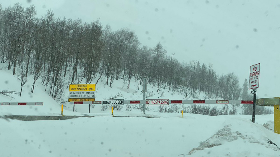
The new snow combined with the several feet of snow already in mountain areas led the Utah Avalanche Center to warn of avalanches. “We’ve issued an avalanche watch (likely a warning by Saturday am) statewide with dangerous avalanche conditions expected through at least this weekend,” the center tweeted.
We’ve issued an avalanche watch (likely a warning by Saturday am) statewide with dangerous avalanche conditions expected through at least this weekend. https://t.co/yxRUDpNtRt#utavy
— UtahAvalancheCenter (@UACwasatch) December 30, 2022
National Weather Service tweeted out, “An Avalanche Watch is in effect for most Utah mountains. Plan to avoid travel in avalanche terrain, as avalanche danger for the watch will likely rise to High.”
UDOT also warned about being on the lookout for, “Backcountry closures and highway avalanche control notifications for Little Cottonwood, Big Cottonwood, and Provo Canyons.”
Road Closure, Provo Canyon US-189 Canyon Glen to Vivian Park,10:00 AM to 2:00 PM 12/31 Intermittent closures https://t.co/aOZSKIkNeB
— UDOT Avalanche (@UDOTavy) December 30, 2022
Friday morning the Utah Department of Transportation announced one canyon closure. “LCC Mid North Side, 9 am to 10 pm 12/30 Gate B to Hellgate Condo,” UDOT tweeted.
More could be on the way based on the forecasts from Johnson and the National Weather Service.
UDOT has set up a website that compiles all of Utah’s avalanche warnings, closures, and traffic impacts. You can access it here.
UTAH’S SKI AREAS
Utah’s ski areas were already celebrating this year’s heavy snowfall and bracing for this next onslaught.
Parking lots filled up early and overflow cars clogged the canyons. Brighton tweeted at 10 am, “Our parking lot is full, please plan your trip accordingly. We usually have spots open around 1-2 pm.”
The start of the next storm has arrived! There’s 3”-5” of snow forecasted throughout the day today with another 20”-30” estimated to fall this the weekend. The Raintree and Lightning Ridge snowcats will be operating today with plenty of fresh untouched snow! pic.twitter.com/SzZmxF0wdk
— Powder Mountain (@PowMow) December 30, 2022
Snowbird prepared for another massive snow dump this weekend.
“We could see anywhere from 42 inches up to 76 inches of snow. A lot of snow in the next few days,” Kelsey James, Snowbird’s creative marketing manager said.
James said they’re keeping critical staff members stationed on the mountain so they don’t end up stuck trying to get up or down the canyon.
Our parking lot is full, please plan your trip accordingly. We usually have spots open around 1-2pm. @UDOTcottonwoods pic.twitter.com/6jseURKRLm
— Brighton Resort (@BrightonResort) December 30, 2022
When ski area roads are closed for avalanche mitigation it forces more cars to park on the road and highlights the need for some sort of a solution. A gondola, buses, and other ideas have been floated.
The Utah Department of Transportation released all public comments on the gondola plan in November. In all, they received 13,443 comments. After a lengthy process, UDOT identified the Gondola as the preferred alternative to improve transportation and environmental impacts in the canyon on Aug. 31.
Skiers have said they’ll gladly enjoy conditions like this and face the gridlock until a plan to fix the traffic issues is figured out.
72-HOUR SNOW KITS FOR DRIVERS
The Weather Service reminded anyone who planned to be out on the roads this weekend to have a 72-hour kit with them.
“The name of the game for disaster preparedness is being prepared,” said Bryan Stinson with the Utah Division of Emergency Management and Be Ready Utah. “That means to do it beforehand.”
A 72-hour kit is recommended for each member of your family, and those kits should be personalized to each member’s needs. For those starting from scratch, kits don’t need to be complicated; start with the basics you can gather around your home — food, water, and warm clothing. For those building a kit for their car, now is a good time to put in a sleeping bag or extra blankets.
Grab a phone charger, flashlight and batteries, as well as a first aid kit and a candle with matches. A single candle can raise the temperature inside a car 10 to 15 degrees, and that could be enough to be a lifesaver.
Be Ready Utah has other suggestions on its website.
Comments are closed.