


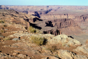
Comb Wash in the Bears Ears National Monument is one of the roadless areas under the American Red Rock Wilderness Act. Photo George Würthner
The 8 million acre wilderness proposal of the Southern Utah Wilderness Alliance (SUWA) p. 1535 “America’s Red Rock Wilderness Act” has just received important support from the Dine or Navajo tribe.

President Biden recently expanded the Bears Ears National Monument. Photo George Würthner
The Navajo Reservation borders many of these public areas that are intended to be designated as wilderness. The areas in the American Red Rock Wilderness Act are of critical cultural and historical importance to the Navajo. The tribe should therefore be commended for supporting the SUWA proposal.

Pothole in the maze, Canyonlands NP. Photo George Würthner
But more importantly, its resolution also draws attention to the serious threat that climate change poses to the planet.
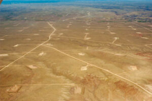
Oil and gas reserves are spread across the country south of Vernal, Utah. Photo George Würthner
“Our support for this Congressional bill sends a message that the Navajo Nation is concerned about climate change and the impact on our environment,” said Delegate Herman Daniels, Jr.

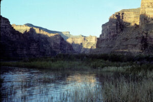
San Juan River. Photo George Würthner
The tribe went on in its statement, saying, “The Navajo Nation Council also recognizes that one of the best tools the US Congress has to help meet the President’s” 30 × 30 “goal is the to legislate the entire qualified, undeveloped public. “Lands in Utah as Wilderness under the Wilderness Act of 1964.”

Labyrinth Canyon. Photo George Würthner
The US Geological Survey estimates that about a quarter of all US carbon emissions come from fossil fuels extracted from public land.
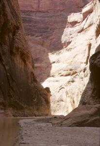
Dirty Devil’s Gorge. Photo George Würthner
The Navajo Council stated that “Wilderness management is one of the strongest and most protective designations of public land, leaving fossil fuels in the ground so that exploration and development do not produce greenhouse gases and other pollution that exacerbates climate change.” the burning of these natural resources. “

Mule Canyon. Photo George Würthner
Scientists estimate that the areas proposed for protection currently store and store 247 million tons of organic carbon in plants and soils.

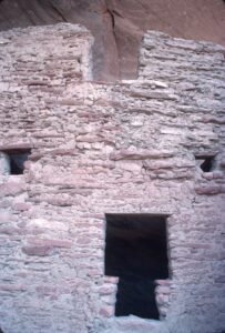
The designation of wilderness protects cultural ruins like this one at Bears Ears National Monument. Photo George Würthner
The tribe also notes that designating the wilderness will preserve the cultural arts, cliff dwellings, and other historical / prehistoric and culturally significant sites of all the ancient people who inhabited the area.
River House ruins, San Juan River Canyon, photo George Wuerthner
Research shows that ancient cultural artifacts are more likely to be vandalized or looted if an ORV route is nearby and wilderness designation precludes ORV and other mechanical access. The Utah Professional Archaeological Council, which advocated the American Red Rock Wilderness Act in 1995, states, “Preserving roadless areas is the greatest and most cost-effective deterrent to pothunting, accidental site run-over, and vandalism.”

America’s Red Rock Wilderness Act was introduced to the Senate by Illinois Senator Dick Durbin to protect one of the most iconic and spectacular landscapes in the world. One of the special features of Canyonland in southern Utah is the combination of expansive views with intimate details in canyon alcoves.

Book Cliffs near Green River, Utah. Photo George Würthner
Legislation includes many proposed wilderness designations within the Bears Ears National Monument, which President Biden recently expanded to protect one of the finest collections of Anasazi ruins.

Grand Gulch is located in the Bears Ears National Monument. Photo George Würthner
Bears Ears suggested wilderness areas include Arch Canyon (approximately 30,500 acres), Fish and Owl Creek Canyon (approximately 74,000 acres), Grand Gulch (approximately 161,000 acres), and Comb Ridge (approximately 16,000 acres).

The Escalante River in the Grand Staircase Escalante National Monument. Photo George Würthner
Large, planned wilderness areas within the Grand Staircase Escalante National Monument (GSENM) include portions of the drainage of the Escalante River and the Kaiparowits Plateau.
The American Red Rock Wilderness Act protects the headwaters of the Paria River. The dark spot in the photo below is a hiker in the depths of Paria Canyon, within the existing Paria Canyon Vermillion Cliffs Wilderness. Photo George Würthner
Significant roadless areas within the GSENM include Paria-Hackberry (approx. 196,000 acres), Death Hollow (approx. 50,000 acres), Paria-Hackberry (approx. 196,000 acres), Upper Kanab Creek (approx. 51,000 acres), Fiftymile Mountain (approx 207,000 acres), North Escalante Canyons (approximately 182,000 acres).

Arch Canyon. Photo George Würthner
Outside of these two monuments, S. 1535 encompasses another important roadless land that includes parts of the Great Basin in the area known as the West Desert of Utah. You can find some awesome mountain ranges here, including the Deep Creek Mountains, Wah Wah Mountains, and House Range.

Deep Creek Range reaches an altitude of 12,000 feet. Photo George Würthner
The protection of Canyonlands National Park is extended by several large roadless areas contained in p. 1535, such as Labyrinth Canyon (approx. 83,000 acres), San Rafael River (approx. 117,000 acres) and Hatch Point Canyons / Lockhart Basin ( approx hectares).

Hikers in a narrow part of Little Wild Horse Canyon, San Rafael Swell. Photo George Würthner
To the west of Canyonlands is the San Rafael Swell. There are some significant wildlife areas here, including Factory Butte (approximately 22,000 acres), San Rafael Reef (approximately 53,000 acres), and Wild Horse Mesa (approximately 63,000 acres).

Morning Glory Arch near Moab. Photo George Würthner
Near Moab, S. 1535 would protect Morning Glory (approximately 11,000 acres, Behind the Rocks (approximately 19,500 acres), Westwater Canyon (approximately 39,000 acres), and Mill Creek (approximately 17,000 acres) with no roads.
Desolation Canyon. Photo George Würthner
The Green River has carved Desolation Canyon through the Book Cliffs north of Green River, Utah. Larger roadless areas within the Book Cliffs are Desolation Canyon (approximately 32,000 acres) and Diamond Canyon (approximately 168,000 acres).

Side Stegner Rafting Desolation Canyon of the Green River. Photo George Würthner
Roadless lands proposed as wilderness in the drainages that flow into the Glen Canyon National Recreation Area include the Dark Canyon (approximately 138,000 acres) and the Dirty Devil (approximately 245,000 acres).

Henry Mountains from Waterpocket Fold. Photo George Würthner
The Henry Mountains rise above the Red Rock Canyon land south of Hanksville and comprise significant roadless areas such as Mount Ellen-Blue Hills (approximately 145,000 acres) and Mount Pennell (approximately 155,000 acres).

The vastness of the Red Rock landscape in southern Utah is unique in the world and must be protected as wilderness forever. Photo George Würthner
All of these areas and many more contained in p.1535 deserve full wilderness protection for all of the reasons the Navajo people endorse the legislation. It will protect wilderness values, cultural resources and wildlife, and most importantly, it will help reduce global warming by keeping carbon in the soil.

Caineville Mesa. Photo George Würthner
Further information can be found on the SUWA website.
![]() Print friendly
Print friendly
Comments are closed.